


Méribel centre - les Allues

XavierFaidix
User
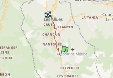

Length
4.3 km

Max alt
1417 m

Uphill gradient
17 m
Km-Effort
5.5 km

Min alt
1119 m

Downhill gradient
299 m
Boucle
No
Creation date :
2022-02-22 13:53:58.626
Updated on :
2022-02-22 20:15:34.997
1h20
Difficulty : Easy

FREE GPS app for hiking
 SityTrail
IGN / Geographical institutes
SityTrail Plus
The world is yours!
About
Trail Walking of 4.3 km to be discovered at Auvergne-Rhône-Alpes, Savoy, Les Allues. This trail is proposed by XavierFaidix.
Positioning
Country:
France
Region :
Auvergne-Rhône-Alpes
Department/Province :
Savoy
Municipality :
Les Allues
Location:
Unknown
Start:(Dec)
Start:(UTM)
309401 ; 5030502 (32T) N.
Comments